Diverse nature sites
Puurijärvi and Isosuo National Park
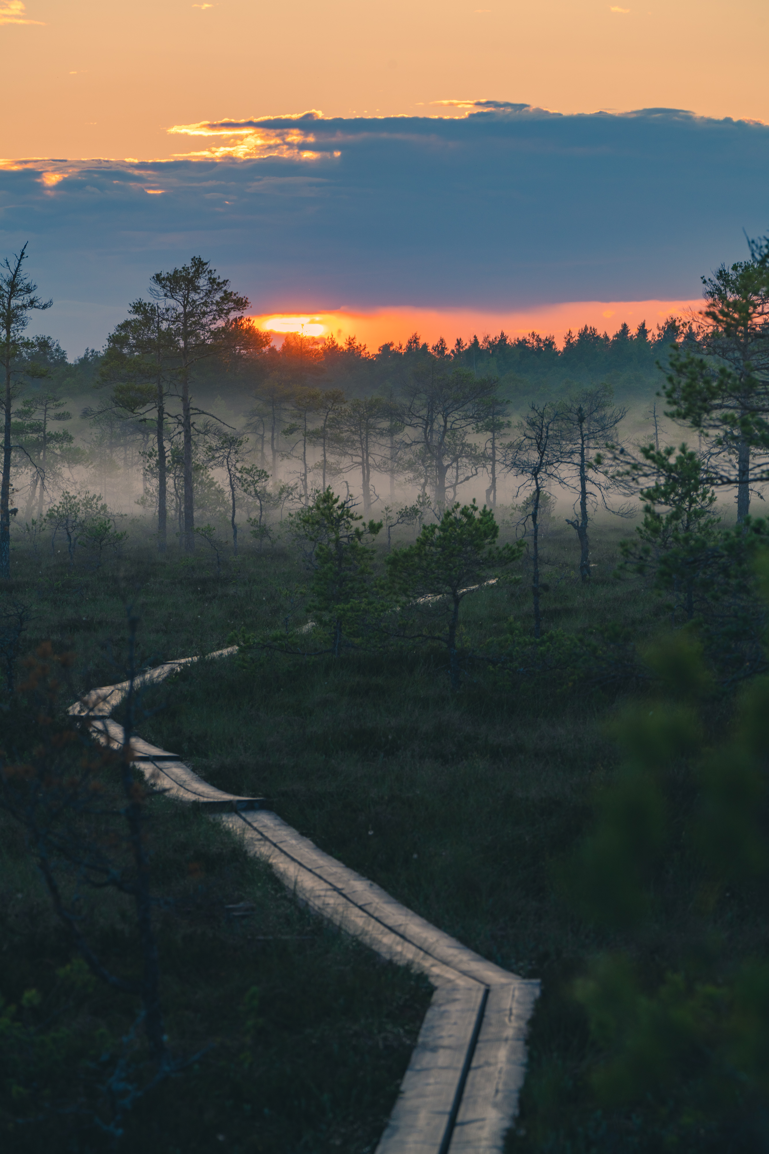
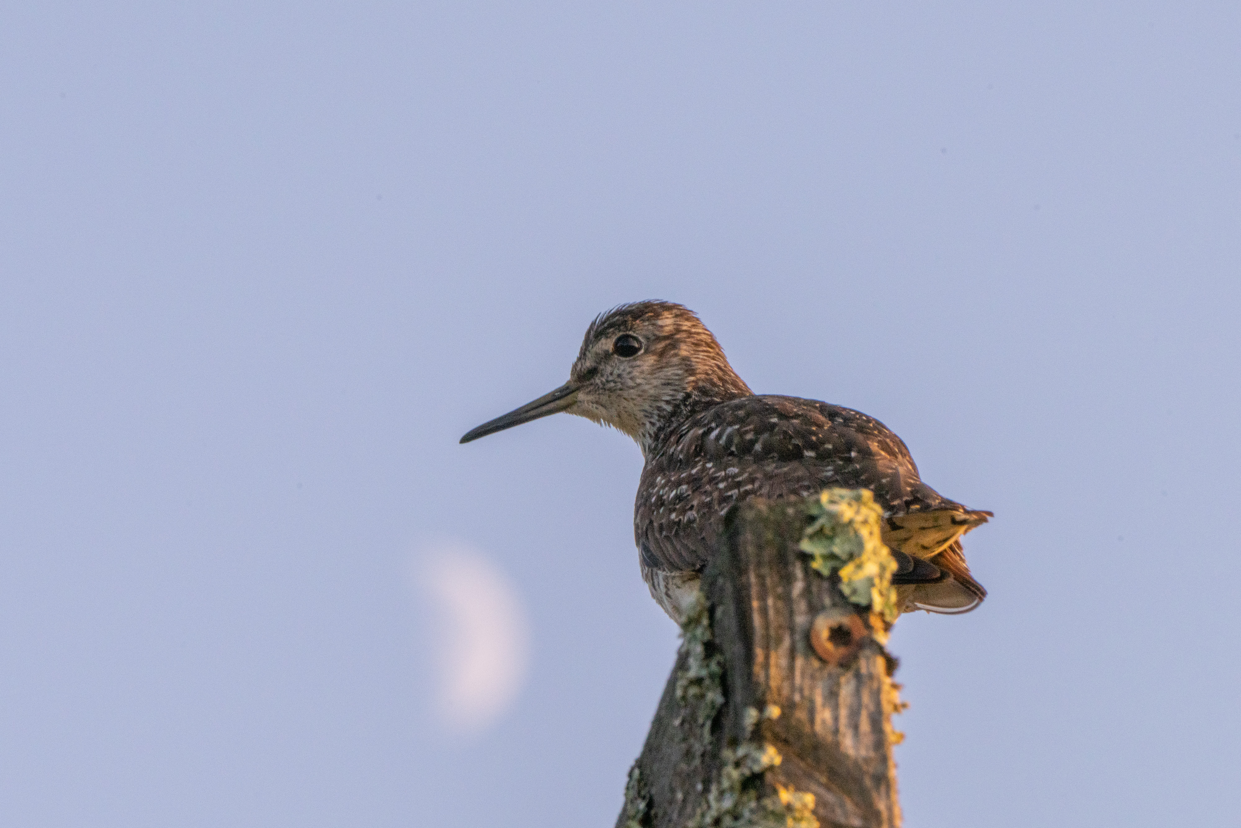
Puurijärvi and Isosuo National Park will enchant you with its cultural landscapes, typical of Satakunta region, and its diversity of bird life. Its lush wetlands and marshes make it a notable bird-watching destination even on the European scale. The Meadow Pipit (Anthus pratensis) and the Yellow Wagtail (Motacilla flava) are the most common bird species of the national park’s marshes. Puurijärvi is a notable rest stop during the spring and autumn migrations of swans, cranes (Grus grus), geese and other aquatic birds. Puurijärvi is also a nesting place for valuable European bird species, such as the Eurasian Bittern (Botaurus stellaris), Marsh Harrier (Circus aeruginosus), Spotted Crake (Porzana porzana) and Black Tern (Chlidonias niger). Three marked routes (0.5–2 km) lead to the bird-watching towers. The largest of the towers at Kärjenkallio is among the largest in all of the Nordic countries.
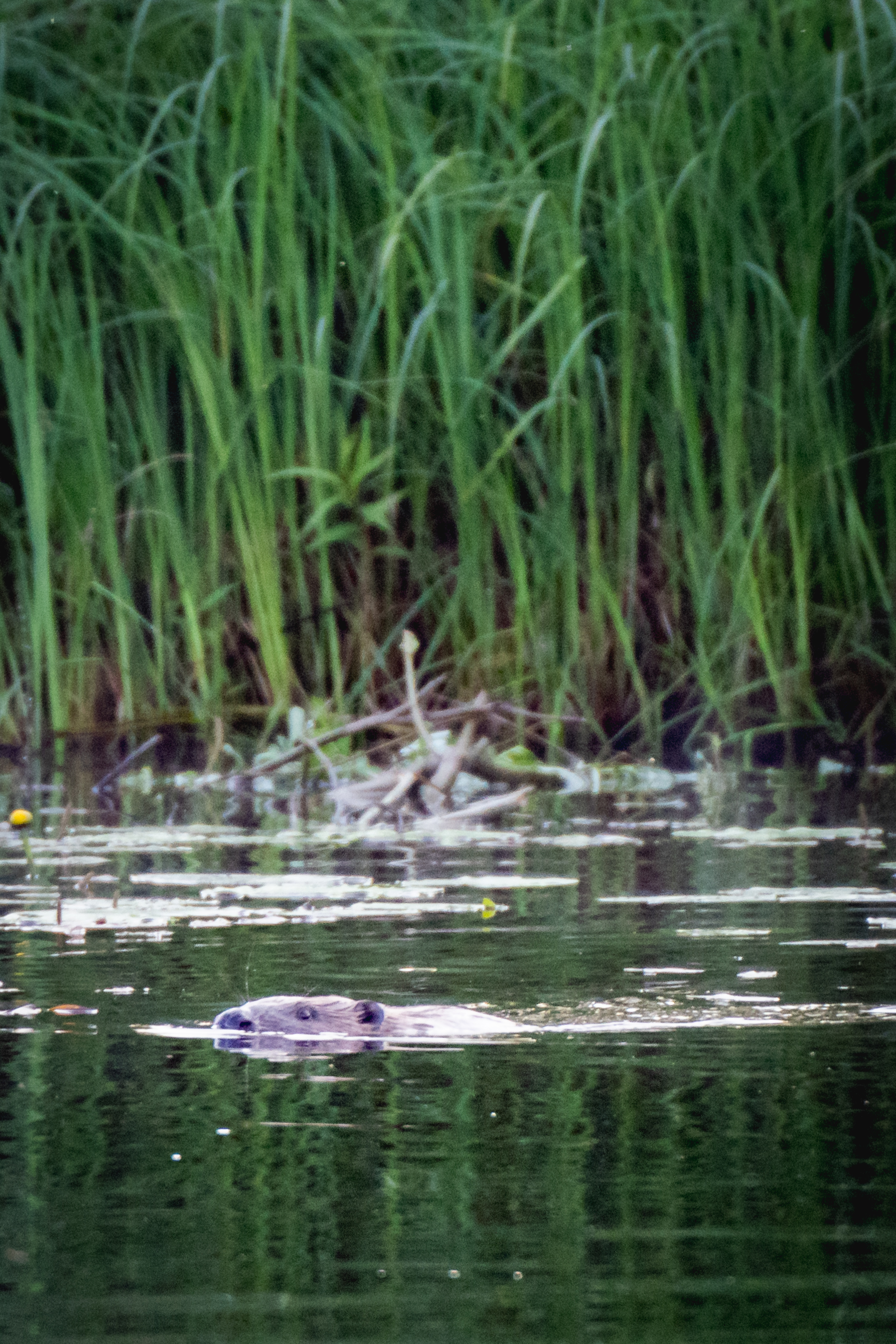
In addition to birds, at the Puurijärvi and Isosuo national park, you can also spot different dragonflies and butterflies as well as the rare Eurasian Beaver (Castor fiber). The national park is also home to Turvesuuli – a storage building used for drying and storing peat. Turvesuuli houses an exhibition on the history of peat collection.
The Puurijärvi and Isosuo National Park is suitable for all ages throughout the year. The Kärjenkallio bird-watching platform and the path leading to it are accessible. You can also reach the national park by water via either the Kokemäenjoki or Ala-Kauvatsanjoki rivers.
Puurijärvi and Isosuo National Park. Photo: Rami Valonen

Puurijärvi and Isosuo National Park. Photo: Rami Valonen

Puurijärvi and Isosuo National Park. Photo: Rami Valonen
Puurijärvi and Isosuo National Park. Photo: Rami Valonen
Puurijärvi and Isosuo National Park. Photo: Rami Valonen
Puurijärvi and Isosuo National Park. Photo: Rami Valonen
Vanhakoski Grove Conservation Area
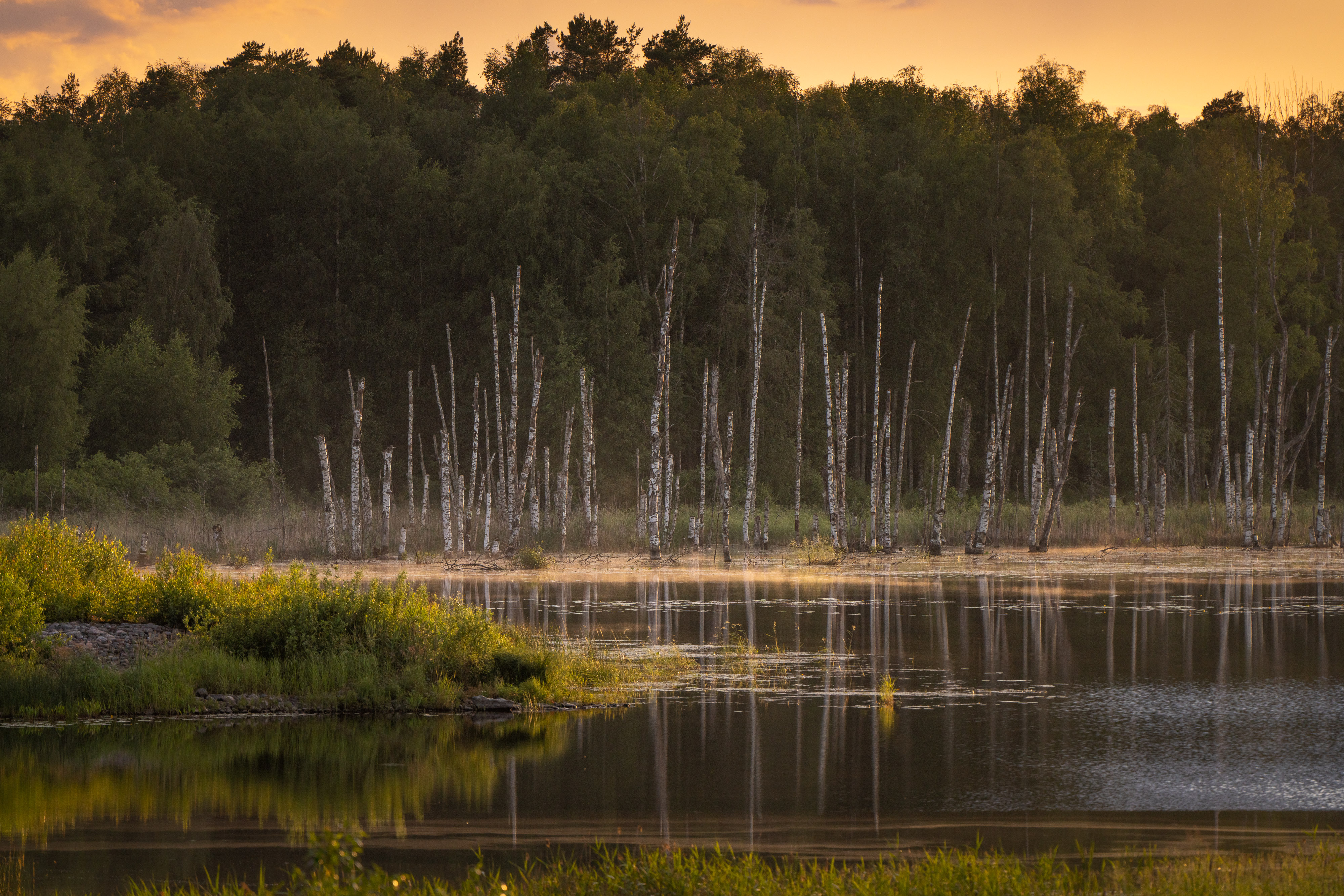
The Vanhakoski Grove Conservation Area offers a perfect setting for enjoying peace of nature. Sit down for a moment to watch the rapids rush by in the midst of old forest and flower-filled meadows. A part of the national grove protection programme, the area is named after rapids that used to flow through the old bed of the Loimijoki river, which dried up after a landslide in 1799 blocked it and the river changed direction, finding its current path. The grove area features fluvial beaches, meadows and moraine mounds. You can also still see the old river bed. Many species of animals and plants have adapted to the old forest and there is diverse bird life in the area. During the summers, sheep graze in parts of the grove area, meadows and forest.
The Vanhakoski grove protection area is also home to the old Saari farm and garden, maintained by support associations. The area features an eight-person overnight lean-to, a campfire site and an accessible outhouse. Please bring your own firewood. Additionally, the outhouse does not have toilet paper, so please remember to bring some.
The Vanhakoski grove area is easy to access on foot, by bike or car. The grove area is located four kilometres from central Huittinen and only a couple of kilometres from the main road number 2. The area makes a great destination for a 2–3 hour trip for families and groups of children.
Location: Vanhankoskentie 118, 32700 Huittinen
Harjureitti
Known as “Little Lapland”, Harjureitti is located in the Säkylänharju-Virttaankangas area, in the middle of the only unbroken ridge of Southwestern Finland. The ridge area features a 28 km outdoor route, of which 14 km is lit. There are several lean-to shelters, a turf hut, the Luppokota hut, rental cabins and a smoke sauna along the route. The route is also very well suited for cross-country skiing and cycling.
The Ripovuori lookout point
The Ripovuori lookout point opens to a beautiful view of the Kokemäenjoki river and a cultural landscape typical to the Satakunta region. Ripovuori has a long history. It used to be an important site of worship and it used to feature bronze-age tumuli. Since 2022, the lookout point has been home to the Leijonankita lean-to shelter. Please bring your own firewood.
Location: Ripovuorentie 58, 32710 Huittinen

Vanhakoski Grove Conservation Area

Vanhakoski Grove Conservation Area. Photo: Janne Arola

Vanhakoski Grove Conservation Area. Photo: Soile Vahela
Porttikallio Outdoor Recreation Area
Located three kilometres from central Punkalaidun, Porttikallio is a versatile outdoor recreation area and nature site. There is a lit fitness track and ski trail. The lit sawdust tracks are 1–2.5 kilometres long. The area also has an outdoor gym with equipment. Porttikallio also features a challenging 18–hole disc golf course of class A1.
The viewing tower at the top of Porttikallio offers an expansive view over the town, stretching as far as the eye can see. There are two campfire sites for the visitors’ use. The nature trail is fairly rocky, but the other routes in the area are fairly wide and suitable for everyone, regardless of age.
Appelqvist dugout
Located on the border of Urjala and Punkalaidun, the Appelqvist dugout blends well into its surroundings, but finding it raises the question: how did such a structure end up in the middle of the forest? The answer can be found inside the stone shelter, in a folder that provides information on the Appelqvist family in general. The life of Frans Mikael Appelqvist features tragic turns starting in his youth and ranging up to the time of his death. The shelter has also a guestbook that visitors are asked to sign.
The Appelqvist dugout is located on the border of Punkalaidun and Urjala. From Punkalaitumentie road, turn to Harituntie road and continue for about 2.5 kilometres. The Harituntie road is followed in places by a stony and grassy forest road, which turns into a forest path towards the end. The Appelqvist dugout is just over a kilometre away and the route is marked with red and yellow ribbons from the Harituntie road to the site.
The Konatun kellari cave
The Konatun kellari cave located in Punkalaidun is a boulder cave. People used the cave for hiding during the allotment system era. It is believed that before people, the lands of Konatun kellari were inhabited by spirits, which would have built the cave itself. Do you dare enter the spirits’ cave?
Directions: From Punkalaidun Municipal Hall (Vesilahdentie 5, 31900 Punkalaidun) go approx. 3,5 km in the direction of Vesilahti, until you turn left towards Rajasuo Metsätie road (opposite Häihäläntie road). At the end of the forest road, continue straight for about 1,3 km until you can leave your car at the right-hand side of the road. Continue straight ahead along the old forest road, turning right at the Y-junction. The route is marked with red and yellow markers on the trees from the car park to Konatun Kellari.
The Urjala hiking trails from Lamminharju to Pölkinvuori
The Pölkinvuori park and the hiking trails of the Aseman Kyläyhdistys Association offer an easy way to experience the diverse nature of Urjala. The hiking trails are suitable for the whole family, well marked and easy to traverse. At nearly the highest point of Pölkinvuori there is a cottage you can rent, with magnificent views. With good weather the visibility can be up to 40 kilometres. A map of the hiking trails and the starting place can be found at parking lot 2 of Pölkinvuori (Ikaalantie 105, 31700 Urjala) or the Lamminharju outdoor recreational area (Huhmarinmäentie 45, 31700 Urjala).
The Urjalankylä Forest Trail
The Urjalankylä Forest Trail offers diverse forest and field landscapes! Halfway along the hiking route, which is about ten kilometres long, you will find a campfire place and a lean-to. Forest fire warnings must be followed when making a fire. The parking and departure point of the route is located at Urjalankylän Koulumaa. Address: Kantalantie 19, 31720 Urjalankylä.
The Urjala nature observation towers: Kortejärvi and Nuutajärvi
The Urjala nature observation towers offer magnificent views of the surrounding nature. On the shores of Kortejärvi Lake, classified as nationally valuable bird area, you can climb a bird-watching tower and stop by the rest area. The Kortejärvi area belongs to a valuable cultural environment with its traditional landscapes and old structures. Kortejärvi is easily accessible from the Taikayöntie route, with signs along Ahojoentie road. Only 1.5 kilometres from the Taikayöntie route, at the end of Ahojoentie road, there is a parking place from which a 200-metre path takes you to the bird-watching tower and the canopy with information about the area.
The nature tower by Nuutajärvi, built in 2019, is accessible on foot from the Nuutajärvi Glass Village via the road that runs through the estate. The tower is located on the other side on Nuutajärventie road from the glass village. Please approach the tower from the reeds as slowly and quietly as possible, because there may be birds right in front of the tower. The first sighting of a moorhen in the area also happened during construction of the tower.
Diverse nature experiences
The rivers and lakes along the Taikayöntie route offer superb opportunities for canoeing. The Kajakkikioski and the Lauhan Kanoottivuokraamo in Huittinen offer kayaks, canoes and SUP boards for rent along with guided tours. Kokemäenjoki river in Huittinen, for example, offers many alternative routes and beautiful small islands. There is also a slowly flowing canoeing route that starts from Urjalankylä. The 53 km route starts from the Astalantie road entry point and ends with the Kuokkalankoski rapids. The Taikayöntie region offers a great environment for horseback riding and there are many stables in the area, such as Huittisten Ratsastuskeskus and Tuorin Ratsutila in Huittinen and Hessitalli in Urjalankylä. The Taikayöntie region is also deer country, as Urjala has the highest concentration of deer in all of Finland. Honkola Hunting and the Valajärvi manor in Urjala offer hunting-tourism services. The latter also offers fishing services. Bicycles are available for rent for example at Unton Tila in Huittinen (electric fatbikes).
Taikayöntie natural phenomena
Taikayöntie offers especially enchanting natural phenomena. The fog lingering over rivers and fields, the magnificent sunrises and sunsets will enchant you with their magical feeling.
Enjoy nature’s peace for example at Kaunisto beach in Urjalankylä village. Photo: Rami Valonen

The Taikayöntie is a quiet and beautiful scenic road, also very well suited for cycling. Photo: Rami Valonen

Urjalankylä forest trail. Photo: Municipality of Urjala

The Taikayöntie region offers a good setting for winter activities. Photo: Rami Valonen
You can swim in the open water, for example, at Kaunisto beach in Urjalankylä. Photo: Rami Valonen

Porttikallio viewing tower. Photo: Rami Valonen